TOURIST PLACES OF KARNATAKA,INDIA
Nagarahole national park:
Nagarahole national park located in kodagu and mysore district in karnataka[South India]
 In 1997, tribal activist groups won a public interest litigation in the Karnataka High Court to halt the setting up of a resort called the Gateway Tusker Lodge planned to be set up by the Taj Group of Hotels. With nearly 125 villages present inside the park, NGOs actively working to protect the tribal communities include, Living Inspiration for Tribals (LIFT), Coorg Organisation of Rural Development (CORD), DEED, FEDINA-VIKASA and Nagarhole Budakattu Janara Hakkustapana Samithi. In 2000, the first relocation attempts initiated by a World Bank funded eco-development project of the local tribal population was begun with 50 tribal people. The relocated families were given land possession certificates for five acres of land and houses at Veeranahosalli, near Hunsur. The state and union government planned to relocate 1,550 tribal families at a cost of Rs. 15.5 crores.


--------------------------------------------------------------------------------------------------------------------------------------------------------------------------------------------------------------------------------------------------------------------


----------------------------------------------------------------------------------------------------------------------------------------------------------------------------------------------------------------------------------------------------


----------------------------------------------------------------------------------------------------------------------------------------------------------------------------------------------------------------------------------------------------
This park was announced the thirty seventh Project Tiger reserve in 1999. It is part of the Nilgiri Biosphere Reserve. The Western Ghats Nilgiri Sub-Cluster of 6,000 km2 (2,300 sq mi), including all of Nagarhole National Park, is under consideration by the UNESCO World Heritage Committee for selection as a World Heritage Site.
The park has rich forest cover, small streams, hills, valleys and waterfalls. The park has a healthy predator-prey ratio, with many tigers, Indian bison and elephants.
Location
The park ranges the foothills of the Western Ghats spreading down the Brahmagiri hills and south towards Kerala state. It lies between the latitudes 12°15'37.69"N and longitudes 76°17'34.4"E. The park covers 643 km2 (248 sq mi) located to the north-west of Bandipur National Park. The Kabini reservoir separates the two parks. Elevations of the park range from 687 to 960 m (2,254 to 3,150 ft). It is 50 km (31 mi) from the major city of Mysore.
Together with the adjoining Bandipur National Park (870 km2 (340 sq mi)), Mudumalai National Park (320 km2 (120 sq mi)) and Wayanad Wildlife Sanctuary (344 km2 (133 sq mi)), it forms the largest protected area in Southern India, totalling 2,183 km2(843 sq mi).
History
The park derives its name from Naga, meaning snake and hole, referring to streams. The park was an exclusive hunting reserveof the kings of the Wodeyar dynasty, the former rulers of the Kingdom of Mysore. It was set up in 1955 as a wildlife sanctuary and later its area increased to 643.39 km (399.78 mi). It was upgraded into a national park in 1988. The park was declared a tiger reserve in 1999.
Climate and ecology
The park receives an annual rainfall of 1,440 millimetres (57 in). Its water sources include the Lakshmmantirtha river, Sarati Hole, Nagar Hole, Balle Halla, Kabini River, four perennial streams, 47 seasonal streams, four small perennial lakes, 41 artificial tanks, several swamps, Taraka Dam and the Kabini reservoir.[3]
Flora & fauna
The vegetation here consists mainly of North Western Ghats moist deciduous forests with (teak and rosewood predominating in the southern parts. There is Central Deccan Plateau dry deciduous forests with Pala indigo and thorny wattle towards the east. There are some sub-montane valley swamp forests with several species of the Eugenia genus.
The main trees found here are the commercially important rosewood, teak, sandalwood and silver oak. Species of trees of the dry deciduous forest include crocodile bark, Lagerstroemia lanceolata (crepe myrtle), Indian kino tree, Grewia tilaefolia, rosewood andaxlewood. Other tree species that are seen in the forests are Lagerstroemia microcarpa (crepe myrtle), kadam, cotton tree,Schleichera trijuga and some species of ficus.
In the understorey, species found growing include Kydia calycina, Indian gooseberry and beechwood, Shrubs like horse nettles, tick clover, Helicteres species and invasive species like lantana and bonesets are found in abundance.
These forests have some conspicuous tree species such as golden shower tree, flame of the forest and clumping bamboo.
The park protects the wildlife of Karnataka. The important predators and carnivores in Nagarhole National Park are the Bengal tiger,Indian leopard, Ussuri dhole (Cuon alpinus alpinus), sloth bear and the striped hyena (Hyaena hyaena). The herbivores are chital,sambar deer, barking deer, four-horned antelope (Tetracercus quadricornis), gaur (Bos gaurus), wild boar (Sus scrofa) and Indian elephant. Nagarhole National Park provides an opportunity to see some of the southern population of gaur (jungle bison). Also, this park in Karnataka is a good place to see elephants in the luxuriant forests and bamboo thickets which they most enjoy. Their total population in southern India is now about 6500, nearly all living in the area where Karnataka, Tamil Nadu and Kerala adjoin in the shadow of the Western Ghats. Other mammals includes the gray langur (Presbytes entellus), bonnet macaque (Macaca radiata),jungle cat, slender loris (Loris tadigradus), leopard cat (Felis bengalensis), civet (Viverricula indica and Paradoxurus hermaphroditus),mongoose (Herpestes fuscus and Herpestes vitticollis), European otter (Lutra lutra), Indian giant flying squirrel (Petaurista petaurista), Indian giant squirrel (Ratufa indica), porcupine, golden jackal, chevrotain (Tragulus meminna), hare and pangolin (Manis crassicaudata). Over 250 species of birds are found at Nagarhole National Park. Besides the enormous variety of woodland birds, there are large congregations of waterfowl in the Kabini river. Birds range from blue-bearded bee-eater, scarlet minivet and Malabar whistling thrush to the more common ospreys, herons and ducks.
- Mammals
Flagship species like Bengal tiger (Panthera tigris tigris), Indian bison or gaur (Bos gaurus) and Indian elephants (Elephas maximus indicus) are found in large numbers inside the park. A study carried out by Dr. Ullas Karanth of the Wildlife Conservation Society has shown that the forests of Nagarhole have three species of predators i.e. tiger, Indian leopard (Panthera pardus fusca) and Asiatic wild dogs (Cuon alpinus alpinus) present at an equivalent density (PA Update 2000).
The park also has a good number of golden jackals (Canis aureus), grey mongoose (Herpestes edwardsi), sloth bears (Melursus ursinus),striped hyena (Hyaena hyaena), spotted deer or chital (Axis axis), sambar (Cervus unicolor), barking deer (Munitacus muntjak), four-horned antelopes (Tetracercus quadricornis) and wild boar (Sus scrofa).
Other mammalian inhabitants include the common palm civet (Paradoxurus hermaphroditus), brown mongoose (Herpestes brachyurus), striped-necked mongoose (Herpestes vitticollis), black-naped hare (Lepus nigricollis), mouse deer, Indian pangolin (Manis crassicaudata), red giant flying squirrel (Petaurista petaurista), Indian porcupine (Hystrix indica), Gray Langur and Indian giant flying squirrel (Petaurista philippensis).

- Birds
Recognised as an Important Bird Area the park has over 270 species of birds including the 'critically endangered' Oriental white-backed vulture (Gyps bengalensis), 'vulnerable' lesser adjutant (Leptopilos javanicus), greater spotted eagle (Aquila changa) and the Nilgiri wood-pigeon (Columba elphinstonii).
'Near threatened' species like darters (Anhniga melanogaster), oriental white ibis (Threskiornis melanocephalus), greater grey headed fish eagle (Icthyophaga ichthyaetus) and red headed vulture (Sarcogyps calvus) too can be found here. Endemics include the blue winged parakeet (Psittacula columboides), Malabar grey hornbill (Ocyceros griseus) and the white bellied treepie (Dendrocitta leucogastra).
Seven of the 15 Biome-10 (Indian Peninsula Tropical Moist Forest) and 21 of the 59 Biome-11 (Indo-Malayan Tropical Dry Zone) species have been noted from here. Some of the birds that can be sighted here include the white cheeked barbet (Megalaima viridis), Indian scimitar babbler (Pomatorhinus horsfieldii), malabar trogan and Malabar whistling thrush (Myiophonus horsfieldii).
Birds commonly seen in drier regions like painted bush quail (Pendicula erythrorhyncha), Sirkeer malkhoa (Phaenicophaeus leschenaultia), ashy prinia (Prinia socialis), Indian robin (Saxicoloides fulicata), Indian peafowl (Pava cristatus) and yellow legged green pigeon (Treron phoenicoptera) can be found here.
- Reptiles
Reptiles commonly found here are mugger (Crocodylus palustris), common vine snake (Ahaetulla nasutus), common wolf snake (Lycodon aulicus), rat snake (Ptyas mucosus), bamboo pit viper (Trimeresurus gramineus), Russell's viper (Daboia russellii), common krait (Bangarus caeruleus), Indian rock python (Python molurus), Indian monitor lizard (Varanus bengalensis) and the common toad (Bufo melanostictus).
- Insects
Extensive studies on the biodiversity of the insect population have been carried out by researchers from the Ashoka Trust for Research in Ecology and the Environment, Bangalore. The insect biodiversity of this park includes over 96 species of dung beetles and 60 species of ants. Unusual species of ants that have been identified include the jumping ants such as Harpegnathos saltator, which are known to jump up to a metre high.
The ant species Tetraponera rufonigra may be useful as a marker for the health of the forests because these ants feed on termites and are abundant in places where there are lots of dead trees. Species of dung beetles identified include the common dung beetle (Onthophagus dama), India's largest beetle, Heliocopris dominus which breeds only in elephant dung and Onthophagus pactolus, a very rare species of dung beetle.
Tribal and native inhabitants
The Jenu Kurubas, primary inhabitants of this forest area, are a tribe in Karnataka state and their traditional practices and rituals are slowly disappearing. The government is restricting their entry inside the National park and forest due to multiple factors including but not limited conservation efforts and bringing the community to the mainstream society.
The Ministry of Home Affairs, Government of India, identified the Jenu Kuruba and the Koraga as tribal groups in Karnataka. The Jenu Kurubas are traditional food gatherers and honey collectors. In Kannada, the term ‘Jenu’ means ‘honey’ and the term ‘kuruba’ generally mean ‘shepherd’. It is derived from the Kannada word ‘kuri’ which means ‘sheep’. The term kuruba is also associated with non-shepherd communities. They speak a variant form of Kannada commonly known as Jenu-nudi within their family kin group, and Kannada with others. They use Kannada script. According to the Census of 1981, the population of Jenu Kuruba community is 34,747 out of which 17,867 are male and 16,880 are female.
The Jenu Kurubas are found scattered in the jungles as with other tribal groups. They are excellent climbers of tree and are skilled in the use of sling, bows and arrows. They demonstrate a strong emotional attachment to the forest as their mother deity and represents a whole way of life. Their food, dress, worship, house, medicine storing articles furniture etc. all are linked with forest. Parts of the tribe which have resisted exposure to modernization still live in thatched huts made of mud, leaves and grass.
The Jenu Kurubas mainly depend on forest for their day-to-day life. They occupy forested regions where for a long period in their history, they lived in isolation but in harmony with nature. They demonstrate significant knowledge of the forest including varied species of flora and fauna and relate to the forest very well. Collecting honey, wax and other forest produce like roots and tubers has been the mainstay of their survival and in recent times they have been found selling them in the market through organized trade groups, both legal and illegal which has led to a furore of angst amongst the conservationists.
Many of the cultural traits they have are common with the neighbouring tribes such as Betta Kuruba / Kadu Kuruba. In the forest the tribes also practice agriculture, the main crops grown are ragi, cow gram, Bengal gram, horse gram and black gram.
In the recent years, a lot of commercialization has occurred due to increase in tourism and fragmentation of forest ranges leading to severe. The tribal communities have long since given up the traditional ways of life and have easily indulged in poaching activities and indiscreet hunting of birds and forest animals. Numerous cases of such assistance provided by the tribal folk to poachers in trying to sell game, live or dead, medicinal herbs have been observed and controlled by the forest department leading to a clash between the tribal communities protected by law and law enforcement agencies. To resolve this conflict and imminent threat to the bio-diversity in this forest, numerous relocation efforts and anti-poaching efforts have been made in the last decade. An increase in poaching was attributed to the tribal support received by poachers in getting guidance from the tribal groups to navigate the forest and tracking game, in exchange for money or other supply of necessaries.
Relocation efforts
In the last decade there has been enormous activity undertaken both by the Government and certain NGOs to relocate tribals to the periphery of the forests. The relocation efforts are part of a larger focus to conserve the existing tiger populations and elephant habitats which were under serious threat due to change in lifestyles of the tribal folk resident within the forests.
There has been much resistance to relocation efforts from the oldest groups of tribals but success has been met in last few years. Many schools and houses with basic amenities like lighting, hospitals and roads being built to support the relocated tribal population.
Threats and Conservation efforts
- Timber smuggling
Threats to the national park come from large scale cutting of sandalwood and teak trees. Timber smuggling, especially sandalwood smuggling, happens quite extensively here. Timber felling has been reported from plantation areas in Kollihadi, Vaddara Modu, Tattikere in Veerahosanahalli and Mettiupe in Kalahalli. Other places where timber felling has been reported include Arekatti, Badrikatte, Bidurukatte, Veerana Hosahalli and Marhigodu ranges. In July 2002 hundreds of trees were cut down in the Veeranahosalli range.[6] Local non-governmental organisations (NGOs) like Kodagu Ekikarana Ranga (KER), Budakattu Krishikara Sangha (BKS) and Budakattu Hakku Sthapana Samiti (BHSS) are working to stop tree felling.
- Cattle disease
Disease outbreaks among the cattle have been recorded. An outbreak of rabies that resulted in four cattle deaths and affecting 25-30 cattle was reported in the first week of September 2005 at G M Halli on the border of Antharasanthe Forest Range in the park.
- Poaching
Poaching of birds and other mammals is another serious issue. A high number of elephant deaths have been reported from this park, with nearly 100 elephants dying between 1991–92 and 2004-05 in the Kodagu and Hunsur Forest Division (PA Update 2005). Elephants are killed for their ivory. A study carried out by Wildlife First! found that nearly 77 elephants were reported dead between 1 January 2000 and 31 October 2002. Another study carried out by the Institute for Natural Resources, Conservation, Education, Research and Training (INCERT) in 2002 revealed that as many as seven elephants had been killed earlier that year.
A study carried out by Dr. ullas karanth and Madhusudan between 1996 and 1997 revealed that hunting was the biggest threat to wildlife in Kudremukh and Nagarhole National Parks. The survey carried out on 49 active and 19 retired hunters revealed that 26 species of wildlife were hunted at an average intensity of 216 hunter days per month per village. As much as 48% of the hunters reported hunting for the 'thrill'. The study showed that in Nagarhole, 16 mammal species weighing over 1 kg were regularly hunted with shotguns and also by traditional methods used by tribal communities.
- Non-payment of forestry staff
A report submitted by The Project Tiger Steering Committee stated that barely 25% of the park's staff were involved in vigilance work, thus putting the park at high risk of both, poaching and tree felling. Irregular payment to the forestry staff has been reported in both Bandipur and Nagarhole National Parks and there have also been reports of improper use of project funds.
- Forest fire
In January, 2012, there was a catastrophic forest fire that destroyed over 6,000 acres (2,400 ha) of forest.
Forest fires and seasonal droughts coupled with water shortage have caused many wild animals to migrate to other greener spaces.
- Human wildlife conflict
human wildlife conflicts due to raids by wild animals and elephants on nearby villages along with the consequent retaliation by the villagers is another important threat to the parks wildlife. In 2001, the Karnataka state government sanctioned Rs 2 crores to dig elephant proof trenches and install solar fencing around the park to prevent elephants from straying into the farmer's fields.
- Human habitations
Nagarahole photoshop
--------------------------------------------------------------------------------------------------------------------------------------------------------------------------------------------------------------------------------------------------------------------
Ranganathittu Bird Sanctuary
It is named after sri ranganatha swamy.This place also known as ''pakshi kaashi of karnataka'' located in mydala district of Karnataka,India.
It is covered with a boundry of 40 hectare It is an iseland on river cauvrey & It is the largest bird sanctuary in the state..Ranganathittu is located three kilometers away from the historic town of Srirangapattana & 16km from mysore.3 lakh peoples visited this Bird Sanctuary.
History of the Park
The ornithologist Dr. Salim Ali observed that the isles @ caurey formed an important nesting ground for birds and he requested kantirava narasimharaja wodeyar of mysore to declare the area a wildlife sanctuary &It was declared bird sanctuary in 1940. Karnataka State Govt. is maintaining the bird sanctuary which include purchase of nearby lands to expand the protected area.
Flooding
The sanctuary with its islets experience heavy flooding during certain rainy seasons when water is released from KRS Dam , due to heavy rains.During heavy flooding boating is suspended and tourists are allowed to watch the nesting birds from a distance. flooding has also damaged some portions of three islands over past few decades.
Flora & Fauna
Flora
Riverine reed beds cover the banks of the islands, while the islands themselves are covered in broadleaf forests, with dominant species being Terminalia arjuna (arjun tree), bamboo groves, and Pandanus trees. Eucalyptus and acacia trees have also been planted, which might lead to long-term eradication of native species. The endemic and threatened lily Iphigenia mysorensis of the family Colchicaceae also grows in the sanctuary.
Fauna
The islands are host to numerous small mammals, including bonnet macaque, colonies of flying fox and common small mammals like common palm civet and Indian gray mongoose and the monitor lizard. The mugger crocodile or marsh crocodile is a common inhabitant of the riverine reed beds and Ranganathittu has largest fresh water crocodile population in Karnataka state.
Birds
Roughly 170 birds have been recorded here. Of these, the painted stork, Asian openbill stork, common spoonbill, woolly-necked stork, black-headed ibis, lesser whistling duck,Indian shag, stork-billed kingfisher, egret, cormorant, Oriental darter, and heron breed here regularly. The great stone plover, and river tern also nest here. The park is home to a large flock of streak-throated swallows. During the months of January and February, more than 30 species of birds are found and the season of the sanctuary is from November to June.About 50 pelicans have made Ranganathittu as their permanent home. Most of the park falls under the Riparian biome, corresponding to the Indomalaya ecozone.
Large numbers
During winter months starting from mid-December, at certain seasons, as many as 40,000 birds congregate in this bird sanctuary and some birds come from Siberia, Latin America and parts of north India.[11] Ranganathittu is a popular nesting site for the birds and about 8,000 nestlings were sighted during June 2011.
Activities
During Ranger guided boat tours of the iselands are available throut the day & are a good way to watch birds,crocodiles,bats and others. the best seasons to visit santuary are during their nest period June-November
Nearest Places
3 km from Srirangapattana & 16km from Mysore
Railway: Srirangapattana
Airport: Mysore
Photo Shop
----------------------------------------------------------------------------------------------------------------------------------------------------------------------------------------------------------------------------------------------------
Mysore palace:
This palace is historical palace in the city of Mysore in Karnataka, southern India. It belongs to the family of the Wodeyars — the royal family of Mysore, who ruled the mysore state from 1399 to 1950. Incorporates an array of courtyards, gardens, and buildings. The palace is in the central region of inner Mysore, facing the Chamundi Hills eastward.
Mysore is commonly described as the City of Palaces. There are about seven palaces inclusive of this; however, Mysore Palace refers specifically to the one within the Old Fort. Built by Yaduraya Wodeyar and Krishnaraja Wodeyar IV , Mysore Palace is one of the famous and the common tourist place 2nd in india after the one of the wonders of the world ''Tajmahal''
It is the ROYAL PALACE OF WODEYARS
Style of architecture is Indo-Saracenic & timings from 10:00 am to 5:30 pm
Krishnaraja Wadiyar III,After the death of Tipu Sultan he made Mysore his capital in May 1799 and he focused on education, religious sites and donating jewels to temples including Melkote. Chamaraja Wodeyar IX was starts ruling on March 25, 1881. He was anointed king by the Governor-General. He was awarded with founding India's first democratic institutions -"Prajapratinidhi Sabhe" with the Mysore representative assembly in 1881.Nalwadi Krishnaraja Wodeyar IV ruled from 1902 to 1940. He was also called by the name Saint King-"Rajarshi" by Mahatma Gandhi. Assisted by dewans Sir M. Visvesvaraya and Sir Mirza Ismail, he Started Asia's first hydro electric project at Shivanasamudra, the KRS dam and the University of Mysore in 1916. Jayachamaraja Wodeyar was the twenty fifth and the last king,and ruled from 1940 to 1950,& agreed to merge the state with the union of India. A musicologist and a philanthropist, he was named Raj Parmukh of Mysore from Jan 26, 1950, a post he held for six years. The present Maharaja is Yaduveer Wadiyar, who was adopted from relatives.
History of mysore palace
Mysore Palace also known as Amba Vilas Palace located at the heart of Mysore city is the most prominent tourist destination of Mysore that attracts millions of visitors round the year next to the Tajmahal . This historical palace housed within the Old Fort facing the Chamunda Hills stands as the official residence of the Wadiyar dynasty who ruled the Kingdom of Mysore from 1399 to 1950. Displaying Indo-Saracenic style of architecture, this sprawling building is a replacement of the old wooden building destroyed by fire in late 19th century. Commissioned by the Krishnarajendra Wadiyar IV, this palatial building comprises of two durbar halls, a number of colossal courtyards, buildings and strikingly beautiful gardens that speak volumes of the splendour of the Wadiyars.
Krishnaraja Wadiyar III,After the death of Tipu Sultan he made Mysore his capital in May 1799 and he focused on education, religious sites and donating jewels to temples including Melkote. Chamaraja Wodeyar IX was starts ruling on March 25, 1881. He was anointed king by the Governor-General. He was awarded with founding India's first democratic institutions -"Prajapratinidhi Sabhe" with the Mysore representative assembly in 1881.Nalwadi Krishnaraja Wodeyar IV ruled from 1902 to 1940. He was also called by the name Saint King-"Rajarshi" by Mahatma Gandhi. Assisted by dewans Sir M. Visvesvaraya and Sir Mirza Ismail, he Started Asia's first hydro electric project at Shivanasamudra, the KRS dam and the University of Mysore in 1916. Jayachamaraja Wodeyar was the twenty fifth and the last king,and ruled from 1940 to 1950,& agreed to merge the state with the union of India. A musicologist and a philanthropist, he was named Raj Parmukh of Mysore from Jan 26, 1950, a post he held for six years. The present Maharaja is Yaduveer Wadiyar, who was adopted from relatives.
Architecture
The palace is a three-storey stone structure made with fine granite, grey in colour, having deep pink marble stones atop and a five-storey tower measuring 145 ft. The size of the palace measures 245 ft. by 156 ft. Designs of the domes illustrate Indo-Saracenic architecture which was applied by the British architects in British India during the late 19th century. It incorporates elements from Indian, Indo-Islamic, Neo-Classical and Gothic revival styles. Three gates of the compound lead to the palace - the front gate (more specifically the East Gate) opens for the VVIPs and otherwise during the Dasara; the South Gate is designated for general public; and the West Gate normally remains open in Dasara. Apart from these the cellar of the palace has many secret tunnels that lead to several confidential areas and other places like the town of Srirangapatna. Several fancy arches adorn the façade of the building with two smaller arches on either side of the central one that is supported with long pillars. A sculpture of the goddess of good luck, prosperity and wealth, Gajalakshmi, with her elephants is seated atop the central arch. The palace facing Chamundi Hills is a manifestation of the devotion of the Maharajas of Mysore towards Goddess Chamundi. The emblem and coat of arms of the Mysore Kingdom adorns the entrance gate and arch. A large, beautiful and well-maintained garden surrounding the palace makes the site even more spectacular.
Events
The renowned Mysore Dasara festival is celebrated in the palace every year. The palace remains illuminated during 10 days of the festival with around 100,000 light bulbs from 7 pm to 10 pm. During the festival royal throne ''golden throne'' decorated with fascinating designs.
Different religious and cultural programs are performed in the palace during this time. On the auspicious day of Mahanavami that is the 9th day, after worshipping the ‘Pattada Katti’ or the royal sword it is taken on a procession with camels and elephants. The conventional Dasara procession initiates from the palace on the 10th day or Vijayadashami with great pomp and zeal, the central attraction of which is the idol of Goddess Chamundeshwari seated on a golden mantapa made of around 750 kg of gold.
Ambavilasa
This room was used by the king as a hall for private audiences. Entry to this opulent hall is through an elegantly carved rosewood doorway inlaid with ivory that opens into a shrine dedicated to Ganesha. The central nave of the hall has ornately gilded columns, stained glass ceilings, decorative steel grills, and chandeliers with fine floral motifs, mirrored in the pietra dura mosaic floor embellished with semi-precious stones. This is where the king would confer with his ministers. It was the chamber in which he gave audience to people deserving special attention.
Gombe thotti
Entry to the palace is through the Gombe Thotti, or Doll’s Pavilion, a gallery of traditional dolls from the nineteenth and early twentieth centuries. The pavilion also houses a fine collection of Indian and European sculpture and ceremonial objects, including a wooden elephant howdah (frame to carry passengers) decorated with 84 kilograms of gold.
Kalyanamantapa
The Kalyana Mantapa, or marriage hall, is a grand, octagonal-shaped pavilion with a multi-hued stained glass ceiling with peacock motifs arranged in geometrical patterns. The entire structure was wrought in Glasgow, Scotland.
The floor also displays a peacock mosaic, designed with tiles from England. Oil paintings illustrating the royal procession and Dasara celebrations of bygone years are displayed on the walls.
Other rooms
The palace houses several rooms of importance. These include:
- The Diwan-e-aam, a public durbar where the general population could meet the king at scheduled times to submit petitions.
- An armory which contains arms used by the members of the royal family. It contains lances, cutlasses, and other 14th century weapons as well as those used in the early twentieth century, such as pistols.
Adress and way
Address: Sayyaji Rao Rd, Agrahara, Chamrajpura, Mysuru, Karnataka
Banglore -Mysorekm]
You Can also visit
Chandramouleshwara Temple
Chowdeshwari Temple
Brindavan Gardens
Chamundeshwari Temple
Mysore Zoo
Jaganmohan Palace
Karanji Lake
Railway Museum Mysore
Kukkarahalli lake
Krishna Raja Sagara
Regional Museum of Natural History Mysore
Folk Lore Museum Mysore
GRS Fantasy Park
Melody World Wax Museum
Mysore Sand Sculpture Museum
Gun House
Chikka Gadiyara(Small Clock Tower)
Sri Nandi Temple
Jayalakshmi Vilas
Kishkindha Moolika Bonsai Garden
Indira Gandhi Rashtriya Manav Sangrahalaya
KrazyBowl
Jayachamarajendra Circle
Vasanth Mahal
Godly Museum
Mysore Medical College Museum
Sri Bhairava Temple
Wellington Lodge
Wet Pets Aquarium
Jayachamaraja Wadiyar Golf Club
Lokaranjan Mahal Palace
R.K.Narayan House
Kings Museu
About Mysore
Chamundi Hill Entrance Arch
Sri Chamundeshwari Temple
Sri Yoga Narasimha Swamy Temple
Ancient Lakshmi Ramana Temple
Ramaswamy Circle
Statue of Chamarajendra Wodeya
Statue of Kuvempu
Sri Ganesha Printing Press Vanivilas Road Agrahara Mysore Karnataka
Sri Kollapuradhamma temp
Chamundi Vihar
High Way Circle
Statue of Krishna Raja Wodeyar
Ganesha TempleSt. Philomena's Church
Statue of Ramakrishna Paramhamsa
Photoshop


----------------------------------------------------------------------------------------------------------------------------------------------------------------------------------------------------------------------------------------------------
Chitradurga fort
Chitradurga Fort or as the British called it Chitaldoorg, is a fortification that straddles several hills and a peak overlooking a flat valley in the Chitradurga District, Karnataka, India. The fort's name Chitrakaldurga, which means 'picturesque fort' in Kannada, is the namesake of the town Chitradurga and its administrative district.[1][2][3]
The fort was built in stages between the 17th and 18th centuries by the dynastic rulers of the region, including the Rashtrakutas, Chalukyas and Hoysalas as well as the Nayakas of Chitradurga, feudal lords in the Vijayanagar Empire. The Nayakas of Chitradurga, or Palegar Nayakas, were most responsible for the expansion of the fort between the 15th and 18th centuries. They were defeated by Hyder Ali at Chitradurga in 1779. Later the fort was expanded and strengthened by Hyder Ali and his son Tippu Sultan,who succeeded Madakari Nayaka V, the last ruler of the Nayaka clan. The fort is built in a series of seven concentric fortification walls with various passages, a citadel, masjid, warehouses for grains and oil, water reservoirs and ancient temples. There are 18 temples in the upper fort and one huge temple in the lower fort. Among these temples the oldest and most interesting is the Hidimbeshwara temple. The masjid was an addition during Hyder Ali’s rule.[1][2][3] The fort's many interconnecting tanks were used to harvest rainwater, and the fort was said to never suffer from a water shortage.[citation needed]
The fort is located 120 km (74.6 mi) from Hampi, the UNESCO World Heritage Site and 200 km (124.3 mi) from Bangalore. Chitradurga railway line is connected to main line at ChikkajajurBangalore/Mysore – Arasikere broad gauge railway line.
A number of inscriptions of the Chalukyas, the Hoysalas and the Vijayanagar kings have been found in and around the fort. These inscriptions trace the history of the fort to the 3rd Millennium B.C. Ashokan period rock edicts found near Brahmagiri also link Chitradurga to the Mauryan Empire during the reign of the royal dynasties of Rashtrakutas, Chalukyas and Hoysalas. However, the area where the fort now exists achieved prominence only under the dynastic rule of the Nayakas of Chitradurga or "Paleygars" (called "little kings") as a feudatory of the Vijayanagar Empire.
Between 1500 AD and 1800 AD, Chitradurga Fort witnessed a turbulent history starting with the Vijayanagar Empire; the empire had gained control of this region from the Hoysalas. Vijayanagar rulers brought the Nayakas, the traditional local chieftains of the area, under their control as their feudatory, until their dynastic reign ended in 1565 A.D. Thereafter, the Nayakas of Chitradurga took independent control of the region and their clan ruled for more than 200 years until the last of their rulers, Madakari Nayaka V, was defeated by Hyder Ali of Mysore Kingdom, in 1779. During all these years, Chitradurga Fort was central to the reign, particularly of the Nayakas.
Timmana Nayaka or Thimmappa Nayaka, a chieftain from Matti, during the rule of Saluva Narasimha, was the first ruler in the hierarchy of the Nayakas of Chitradurga. Initially, he was a chieftain under the Vijayanagar Empire but was soon elevated to the rank of Governor of Chitradurga by the Vijayanagar ruler in recognition of his excellent provence in military service to the empire. His rule covered areas of the Chitradurga Districtincluding Davangere,Jaglur and Harihar of present Davangere District. His rule lasted for a brief period and ended with his incarceration and death in the jail of the Vijaynagar Empire. His son Obana Nayaka or Madakari Nayaka (1588–1602) succeeded him. Madakari Nayaka was followed by a series of hierarchical or other adopted forms of successions of the same clan; Madakari Nayaka V was the final ruler of the clan from 1758 to 1779. Bharamappa Nayaka, who ruled from 1689 until 1722, is regarded as the greatest of the Nayaka rulers famed for building forts, palaces, tanks and temples, including several gateways and bastions. He fought several battles against the Mughals.
However, it was during the reign of Madakari Nayaka V (1758 to 1779) that the city of Chitradurga and the fort were besieged by the troops of Hyder Ali. Madakari Nayaka used the fort effectively for defense during three battles against Hyder Ali.[1] At times he had allied himself with Hyder Ali of Mysore Kingdom and at other times with the Marathas. Hyder Ali attacked the Chitradurga Fort the first time in 1760, the second time in 1770 and the third time successfully in 1779 when he defeated Madakari Nayaka. Nayaka was taken a prisoner and killed. Nayaka's gamble of playing with both Hyder Ali and the Marathas did not work out. He was betrayed by the Marathas and some local Muhammadan officers in his service. Subsequent to his death the treasury at the fort is said to have yielded a rich bounty. It was during one such war that the heroics of Onake Obavva, the wife of a soldier guarding the fort, became a legendary event.
The dynastic reign of the Nayakas lasted for over 200 years and the Chitradurga fort was their stronghold and the very heart of their province.
In the Fourth Mysore War, Tippu Sultan was killed by the British in 1799, and the Mysore Kingdom was reordered under the Wodeyars. Chitradurga became a part of Mysore province. The British considered Chitradurga Fort a potentially useful base for providing a strong line of defense to Mysore's northern border. Between 1799 and 1809, the British garrisoned their troops in the fort. Later, the control of the fort was restored to the Government of Mysore.
Further information: Hidimbi
Folk legend links the hills surrounding the fort to the epic Mahabharata. It is said that a man-eating giant named Hidimbasura lived on the Chitradurga hill and had terrorized everyone around. When the Pandavas came with their mother Kunti in the course of their exile, Bhima had a duel with Hidimba. Hidimba was slain by Bhima and peace returned to the area. Legend further states that the boulders were part of the arsenal used during that duel.
Chitradurga Fort - KARNATAKA
N. view of the hill-fort of Chitaldrug (Mysore)..JPG E. view of the hill fort of Chitaldrug (Mysore).JPG
North view of the hill fort of Chitradurg East view of the hill fort of Chitradurg
The Nayak Palegars built the fort as an impregnable fortification for defense purposes with 19 gateways, 38 posterior entrances, 35 secret entrances, four invisible passages, water tanks and 2000 watch towers to guard and keep vigil on the enemy incursions. The storage warehouses, pits and reservoirs were primarily designed to ensure the food, water and military supplies required to endure a long siege. Uniquely, all these facilities are still well conserved.[3] Seven walls (called Yelusuttinakote in local language) form the fort. Each wall has a gate with an ascending access through winding narrow corridors which would make it difficult to use elephants for attacking the fort or to use “battering rams” to break down the gates. Small embrasures in the fort walls were provided for use by archers to shoot arrows at the enemy. Four gates were provided in the outermost walls. The four gates (called Bagilu in Kannada) are Rangayyana Bagilu, Siddayyana Bagilu, Ucchangi Bagilu and Lalkote Bagilu. Among the elaborate gateways, the gateway to the east of the fort has architectural features typical of the Bahmani Sultanate. Depending on the topography and the geological strata of the land, the fort walls were built with height ranging from 5–13 metres (16–43 ft). Initially, it was built in mud but was subsequently strengthened in stretches with granite stone slabs in the 18th century. An outstanding feature noticed in several stretches of the fort walls is that no cementing material was used in joining the large granite cubes that have been neatly sized, cut, trimmed and placed in position. The total length of the fort walls is about 8 kilometres (5.0 mi) and covers an area of about 1,500 acres (610 ha). It is also said that when the upper fort was strengthened for military purposes with gun positions, the services of French mercenaries were used.[2][3][5][8] The massive 'Palace of Stones' fort contained many buildings and many temples set in the rocky surroundings on the hill. Madakari Nayaka V, the last ruler of the Nayakas of Chitradurga, utilized the fort successfully for defense until he was defeated by Hyder Ali in 1779. The fort thus stands as a tribute to the Nayakas who ruled this part of Karnataka.[3]
Subsequent additions to the forts were built with burnt bricks, set in mortar, plastered by a thin layer of cement or lime, and painted. However, the fort now shows deterioration. The mud brick walls of the storehouses and granaries at the fort are getting eroded due to monsoon rains.[3]
AMAZING AND IMPRESSIVE CHITRADURGA FORT
Entrance to Hidimbeswara Temple. Hidimba and Hidimbi are stated to have lived here
Eighteen temples were built in the upper fort. Some of the well known temples were the Hidimbeswara (an ancient legend is linked to it), Sampige Siddeshwara, Ekanathamma, Phalguneshwara, Gopala Krishna, Lord Hanuman, Subbaraya and Nandi.[citation needed]
Hidimbeswara temple displays the tooth of Hidimba, the giant (Rakshasa in Sanskrit). It is said that Hidimba and his sister Hidimbi, a giantess, used to live in this temple. Hidimbi, who fell in love with Bhima (the second of the Pandava brothers of Mahabharata) married him and had a child by him named Ghatotkacha. A large cylinder about 3 metres (9.8 ft) in circumference and 2 metres (6.6 ft) high made of iron plates known as Bheri or Drum of Bheema is also located here.[citation needed] A monolithic pillar and two swing frames are also seen at the gate to this temple. Sampige Siddheshvara temple is at the foot of the hill. In the Gopalakrishna Temple, inscriptions date the idol to the early 14th century.[3]
In the lower fort, a temple dedicated to the tutelary deity of the Nayaka Palegars, the Uchchangiamma or Uthsavamba, was built amidst the rocks of the fort complex on the hill.[citation needed]
The Murugarajendra Matha, a famous religious institution of the Lingayats, which was originally located within the fort, is now situated about 2 kilometres (1.2 mi) to the northwest of Chitradurga.[9]
One of the tanks in the cascade development in the precincts of the fort
Rainwater-harvesting structures were built in a cascade development, which ensured large storage of water in interconnected reservoirs. It is said that the fort precincts never faced any water shortage.[citation needed]
Historical linkage has been established by an archeological inscription dated 1284 AD found in the Panchalinga (Five Lingas) cave in the Ankhi Matha area, to the west of Chitradurga. The inscription attributes the establishment of the Five Lingas, (aniconic symbols of Lord Shiva), to the Pandavas. At Ankhi Matha, approached by stone steps, a series of ancient subterranean chambers cut out at different levels are seen, in addition to several places of worship and platforms.[citation needed]
In the lower fort, a Cutcherry (administrative office) was added during Tippu Sultan’s rule. Another interesting find in the arsenal is a quadruple mill made of masonry of 3 metres (9.8 ft) depth and about 7 metres (23 ft) diameter, which is inferred to be a device used for preparing gunpowder during Hyder Ali and Tippu Sultan’s rule.[citation needed] In Kannada language, it is called 'Maddu Bisuva Kallu', which means "gunpowder grinding stone". The quadruple mill has four massive grinders with teeth or slots. These were rotated either by elephants or bullocks (in a central circular space) with an independent collection point for each of the four slots to collect the explosive gunpowder.[citation needed]


--------------------------------------------------------------------------------------------------------------------------------------------------------------------------------------------------------------------------------------------
Later Bandipur National Park joined its hands with its other neighboring parks, the Nagarhole National Park (643 sq km), Madumalai National Park (320 sq km) and Wayanad Wildlife Sanctuary (344 sq km) together to form the essential part of Nilgiri Biosphere Reserve making the area as the largest wildlife protected zone.
Geography Deccan Plateau meets the Western Ghats and the altitude of the park ranges from 680 meters to 1,454 meters . As a result, the park has a variety of biomes including dry deciduous forests, moist deciduous forests and shrublands. The wide range of habitats help support a diverse range of organisms. The park is flanked by the Kabini river in the north and the Moyar river in the south. The Nugu river runs through the park. The highest point in the park is on a hill called Himavad Gopalaswamy Betta, where there is a Hindu temple at the summit. Bandipur has typical tropical climate with distinct wet and dry seasons. The dry and hot period usually begins in early March and can last till the arrival of the monsoon rains in June.FloraThe area is blooming with great varieties of timber trees including: Teak (Tectona grandis), Sandalwood (Santalum album V), Rosewood (Dalbergia latifolia), Indian Kino Tree (Pterocarpus marsupium), giant clumping bamboo (Dendrocalamus strictus), Indian-laurel (Terminalia tomentosa), clumping bamboo (Bambusa arundinacea) and Grewia tiliaefolia.Apart from such variety, there are also several notable flowering and fruiting trees and shrubs holding the arena like: Indian Gooseberry (Emblica Officinalis), Kadam Tree (Adina Cordifolia), Crape-myrtle (Lagerstroemia Lanceolata), Axlewood (Anogeissus latifolia), Black Myrobalan (Terminalia chebula), Schleichera Trijuga, Odina Wodiar, Flame of the Forest (Butea Monosperma), Golden Shower Tree (Cassia fistula), Black Cutch (Acacia catechu), Shorea Talura (E), Indigo Berry (Randia uliginosa), Satinwood (Chloroxylon Swietenia).Fauna


The fort was built in stages between the 17th and 18th centuries by the dynastic rulers of the region, including the Rashtrakutas, Chalukyas and Hoysalas as well as the Nayakas of Chitradurga, feudal lords in the Vijayanagar Empire. The Nayakas of Chitradurga, or Palegar Nayakas, were most responsible for the expansion of the fort between the 15th and 18th centuries. They were defeated by Hyder Ali at Chitradurga in 1779. Later the fort was expanded and strengthened by Hyder Ali and his son Tippu Sultan,who succeeded Madakari Nayaka V, the last ruler of the Nayaka clan. The fort is built in a series of seven concentric fortification walls with various passages, a citadel, masjid, warehouses for grains and oil, water reservoirs and ancient temples. There are 18 temples in the upper fort and one huge temple in the lower fort. Among these temples the oldest and most interesting is the Hidimbeshwara temple. The masjid was an addition during Hyder Ali’s rule.[1][2][3] The fort's many interconnecting tanks were used to harvest rainwater, and the fort was said to never suffer from a water shortage.[citation needed]
Etymology
Chitradurga is formed of two words in the Kannada language: ‘chitra’ means “picture” and ‘durga’ means “fort” and is tagged with the English word ‘fort’ to form the name “Chitradurga Fort”. It is also locally known as “Kallina Kote” or Stone Fortress, which is also formed of two Kannada words ‘Kallina’: “Stone” and Kote:“Fort”. Other names used in Kannada are ‘Ukkina Kote”: “Steel Fort” (metaphorically used to mean an impregnable fort) and ‘Yelusuttina Kote’: “Seven Circles FortGeography
Chitradurga Fort lies in the midst of a valley formed by the Vedavati River. The Tungabhadra River flows to the northwest of the fort. Seven hills constitute the Chinmuladri range. The seven circles of the fort enclose these hills. Features of massive rock hills and scenic valleys, huge towering boulders are seen in the fort precincts. The hills on which major part of the fort and the city rest belong to the oldest rock of granitic formation in the country. The highest hill peak of the area is located at Jogi Matti, 5 kilometres (3.1 mi) to the south of Chitradurga.[2] The highest elevation of the hills at the fort is 976 metres (3,202 ft).[4] The area covered by the fort is reported to be 1,500 acres (607.0 ha).The fort is located 120 km (74.6 mi) from Hampi, the UNESCO World Heritage Site and 200 km (124.3 mi) from Bangalore. Chitradurga railway line is connected to main line at ChikkajajurBangalore/Mysore – Arasikere broad gauge railway line.
History
Further information: Nayakas of ChitradurgaA number of inscriptions of the Chalukyas, the Hoysalas and the Vijayanagar kings have been found in and around the fort. These inscriptions trace the history of the fort to the 3rd Millennium B.C. Ashokan period rock edicts found near Brahmagiri also link Chitradurga to the Mauryan Empire during the reign of the royal dynasties of Rashtrakutas, Chalukyas and Hoysalas. However, the area where the fort now exists achieved prominence only under the dynastic rule of the Nayakas of Chitradurga or "Paleygars" (called "little kings") as a feudatory of the Vijayanagar Empire.
Between 1500 AD and 1800 AD, Chitradurga Fort witnessed a turbulent history starting with the Vijayanagar Empire; the empire had gained control of this region from the Hoysalas. Vijayanagar rulers brought the Nayakas, the traditional local chieftains of the area, under their control as their feudatory, until their dynastic reign ended in 1565 A.D. Thereafter, the Nayakas of Chitradurga took independent control of the region and their clan ruled for more than 200 years until the last of their rulers, Madakari Nayaka V, was defeated by Hyder Ali of Mysore Kingdom, in 1779. During all these years, Chitradurga Fort was central to the reign, particularly of the Nayakas.
Timmana Nayaka or Thimmappa Nayaka, a chieftain from Matti, during the rule of Saluva Narasimha, was the first ruler in the hierarchy of the Nayakas of Chitradurga. Initially, he was a chieftain under the Vijayanagar Empire but was soon elevated to the rank of Governor of Chitradurga by the Vijayanagar ruler in recognition of his excellent provence in military service to the empire. His rule covered areas of the Chitradurga Districtincluding Davangere,Jaglur and Harihar of present Davangere District. His rule lasted for a brief period and ended with his incarceration and death in the jail of the Vijaynagar Empire. His son Obana Nayaka or Madakari Nayaka (1588–1602) succeeded him. Madakari Nayaka was followed by a series of hierarchical or other adopted forms of successions of the same clan; Madakari Nayaka V was the final ruler of the clan from 1758 to 1779. Bharamappa Nayaka, who ruled from 1689 until 1722, is regarded as the greatest of the Nayaka rulers famed for building forts, palaces, tanks and temples, including several gateways and bastions. He fought several battles against the Mughals.
However, it was during the reign of Madakari Nayaka V (1758 to 1779) that the city of Chitradurga and the fort were besieged by the troops of Hyder Ali. Madakari Nayaka used the fort effectively for defense during three battles against Hyder Ali.[1] At times he had allied himself with Hyder Ali of Mysore Kingdom and at other times with the Marathas. Hyder Ali attacked the Chitradurga Fort the first time in 1760, the second time in 1770 and the third time successfully in 1779 when he defeated Madakari Nayaka. Nayaka was taken a prisoner and killed. Nayaka's gamble of playing with both Hyder Ali and the Marathas did not work out. He was betrayed by the Marathas and some local Muhammadan officers in his service. Subsequent to his death the treasury at the fort is said to have yielded a rich bounty. It was during one such war that the heroics of Onake Obavva, the wife of a soldier guarding the fort, became a legendary event.
The dynastic reign of the Nayakas lasted for over 200 years and the Chitradurga fort was their stronghold and the very heart of their province.
In the Fourth Mysore War, Tippu Sultan was killed by the British in 1799, and the Mysore Kingdom was reordered under the Wodeyars. Chitradurga became a part of Mysore province. The British considered Chitradurga Fort a potentially useful base for providing a strong line of defense to Mysore's northern border. Between 1799 and 1809, the British garrisoned their troops in the fort. Later, the control of the fort was restored to the Government of Mysore.
Brave woman
A woman named Obavva, the wife of a soldier called Maddha Hanumappa, was guarding a fort tower, substituting for her husband during a lunch break. She was guarding the Chitradurga Fort at a crack opening, a secret opening where only one person could barely squeeze through. Her heroics have entered the annals of legendary folklore of the Karnataka State. While fetching water, she heard the muted sounds of enemy soldiers attempting to enter the fort through the crevice. With great presence of mind she immediately hid behind the crevice in the fort and hit at each soldier trying to squeeze through the crevice with onake, the name given in Kannada to a masse or pestle, a wooden rod used for pounding paddy. In this process, she bravely killed several enemy soldiers. By the time her husband appeared on the scene, she had already dragged several bodies of dead soldiers into the fort wall and was standing around the dead bodies with the blood stained onake in her hand. Maddha Hanumappa blew the bugle, and other soldiers joined him and killed all the enemy soldiers. This brave act saved the fort on that day from further attacks by Hyder Ali’s soldiers. Her heroic act was commemorated with her impressive statue (sculpted by Ashok Gudigar) erected in front of the District Commissioner’s office in Chittradurga town. The stadium in the town was named after her. This act earned her the epithet "Onake Obavva" and the crevice in the fort where she showed her bravery is called "Onake Kindi". However, in the battle for the fort, Madakari Nayaka V lost and Chitradurga Fort eventually fell to Hyder Ali in 1779.[3]
Legend
Further information: HidimbiFolk legend links the hills surrounding the fort to the epic Mahabharata. It is said that a man-eating giant named Hidimbasura lived on the Chitradurga hill and had terrorized everyone around. When the Pandavas came with their mother Kunti in the course of their exile, Bhima had a duel with Hidimba. Hidimba was slain by Bhima and peace returned to the area. Legend further states that the boulders were part of the arsenal used during that duel.
Chitradurga Fort - KARNATAKA
Fort precincts
Formidable Chitradurg Fort – views from the north and the eastN. view of the hill-fort of Chitaldrug (Mysore)..JPG E. view of the hill fort of Chitaldrug (Mysore).JPG
North view of the hill fort of Chitradurg East view of the hill fort of Chitradurg
The Nayak Palegars built the fort as an impregnable fortification for defense purposes with 19 gateways, 38 posterior entrances, 35 secret entrances, four invisible passages, water tanks and 2000 watch towers to guard and keep vigil on the enemy incursions. The storage warehouses, pits and reservoirs were primarily designed to ensure the food, water and military supplies required to endure a long siege. Uniquely, all these facilities are still well conserved.[3] Seven walls (called Yelusuttinakote in local language) form the fort. Each wall has a gate with an ascending access through winding narrow corridors which would make it difficult to use elephants for attacking the fort or to use “battering rams” to break down the gates. Small embrasures in the fort walls were provided for use by archers to shoot arrows at the enemy. Four gates were provided in the outermost walls. The four gates (called Bagilu in Kannada) are Rangayyana Bagilu, Siddayyana Bagilu, Ucchangi Bagilu and Lalkote Bagilu. Among the elaborate gateways, the gateway to the east of the fort has architectural features typical of the Bahmani Sultanate. Depending on the topography and the geological strata of the land, the fort walls were built with height ranging from 5–13 metres (16–43 ft). Initially, it was built in mud but was subsequently strengthened in stretches with granite stone slabs in the 18th century. An outstanding feature noticed in several stretches of the fort walls is that no cementing material was used in joining the large granite cubes that have been neatly sized, cut, trimmed and placed in position. The total length of the fort walls is about 8 kilometres (5.0 mi) and covers an area of about 1,500 acres (610 ha). It is also said that when the upper fort was strengthened for military purposes with gun positions, the services of French mercenaries were used.[2][3][5][8] The massive 'Palace of Stones' fort contained many buildings and many temples set in the rocky surroundings on the hill. Madakari Nayaka V, the last ruler of the Nayakas of Chitradurga, utilized the fort successfully for defense until he was defeated by Hyder Ali in 1779. The fort thus stands as a tribute to the Nayakas who ruled this part of Karnataka.[3]
Subsequent additions to the forts were built with burnt bricks, set in mortar, plastered by a thin layer of cement or lime, and painted. However, the fort now shows deterioration. The mud brick walls of the storehouses and granaries at the fort are getting eroded due to monsoon rains.[3]
AMAZING AND IMPRESSIVE CHITRADURGA FORT
Temples in the fort
Entrance to Hidimbeswara Temple. Hidimba and Hidimbi are stated to have lived here
Eighteen temples were built in the upper fort. Some of the well known temples were the Hidimbeswara (an ancient legend is linked to it), Sampige Siddeshwara, Ekanathamma, Phalguneshwara, Gopala Krishna, Lord Hanuman, Subbaraya and Nandi.[citation needed]
Hidimbeswara temple displays the tooth of Hidimba, the giant (Rakshasa in Sanskrit). It is said that Hidimba and his sister Hidimbi, a giantess, used to live in this temple. Hidimbi, who fell in love with Bhima (the second of the Pandava brothers of Mahabharata) married him and had a child by him named Ghatotkacha. A large cylinder about 3 metres (9.8 ft) in circumference and 2 metres (6.6 ft) high made of iron plates known as Bheri or Drum of Bheema is also located here.[citation needed] A monolithic pillar and two swing frames are also seen at the gate to this temple. Sampige Siddheshvara temple is at the foot of the hill. In the Gopalakrishna Temple, inscriptions date the idol to the early 14th century.[3]
In the lower fort, a temple dedicated to the tutelary deity of the Nayaka Palegars, the Uchchangiamma or Uthsavamba, was built amidst the rocks of the fort complex on the hill.[citation needed]
The Murugarajendra Matha, a famous religious institution of the Lingayats, which was originally located within the fort, is now situated about 2 kilometres (1.2 mi) to the northwest of Chitradurga.[9]
koti raja adventure in chitradurga fort
Other structures
One of the tanks in the cascade development in the precincts of the fort
Rainwater-harvesting structures were built in a cascade development, which ensured large storage of water in interconnected reservoirs. It is said that the fort precincts never faced any water shortage.[citation needed]
Historical linkage has been established by an archeological inscription dated 1284 AD found in the Panchalinga (Five Lingas) cave in the Ankhi Matha area, to the west of Chitradurga. The inscription attributes the establishment of the Five Lingas, (aniconic symbols of Lord Shiva), to the Pandavas. At Ankhi Matha, approached by stone steps, a series of ancient subterranean chambers cut out at different levels are seen, in addition to several places of worship and platforms.[citation needed]
In the lower fort, a Cutcherry (administrative office) was added during Tippu Sultan’s rule. Another interesting find in the arsenal is a quadruple mill made of masonry of 3 metres (9.8 ft) depth and about 7 metres (23 ft) diameter, which is inferred to be a device used for preparing gunpowder during Hyder Ali and Tippu Sultan’s rule.[citation needed] In Kannada language, it is called 'Maddu Bisuva Kallu', which means "gunpowder grinding stone". The quadruple mill has four massive grinders with teeth or slots. These were rotated either by elephants or bullocks (in a central circular space) with an independent collection point for each of the four slots to collect the explosive gunpowder.[citation needed]
Photoshop
--------------------------------------------------------------------------------------------------------------------------------------------------------------------------------------------------------------------------------------------
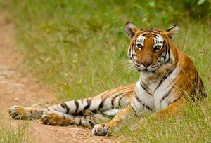
Bandipur national park
It was established as a tiger reserve in the year 1974, Bandipur National Park is well known for its breathtaking natural beauty.
Bandipur National Park was once the hunting reserve for the Maharaja of the Kingdom of Mysore. Established in the year 1974 as a forest tiger reserve under the Project Tiger, Bandipur is the most prominent national park located in the south Indian state of Karnataka and is best known for its varied wildlife boasting different biomes in the dry deciduous forest. It is considered as one of the best managed parks of India.
The park spans an area of 874 square kilometers (337 sq mi), protecting several species of India's endangered wildlife. Together with the adjoining Nagarhole National Park (643 km2 (248 sq mi)), Mudumalai National Park (320 km2 (120 sq mi)) and Wayanad Wildlife Sanctuary (344 km2 (133 sq mi)), it is part of the Nilgiri Biosphere Reserve totaling 2,183 km2 (843 sq mi) making it the largest protected area in southern India and largest habitate of wild elephants in south Asia.
Bandipur is located in Gundlupet taluq of Chamarajanagar district. It is about 80 kilometers (50 mi) from the city of Mysore on the route to a major tourist destination of Ooty.[2] As a result, Bandipur sees a lot of tourist traffic and there are many wildlife fatalities caused by speeding vehicles that are reported each year.[3] There is a ban on traffic from 9 pm to 6 am of dusk to dawn to help bring down the death rate of wildlife.
Hostory
The Bandipur Sanctuary was created by the Maharaja of the kingdom of Mysore in the year 1931. It was during that period when only 90 sq km of the area was being used and was named as Venugopala Wildlife Park. In the year 1973 around 800 sq kms of area was introduced to the Venugopala Wildlife Park and was established as Bandipur Tiger Reserve under the tiger project.Later Bandipur National Park joined its hands with its other neighboring parks, the Nagarhole National Park (643 sq km), Madumalai National Park (320 sq km) and Wayanad Wildlife Sanctuary (344 sq km) together to form the essential part of Nilgiri Biosphere Reserve making the area as the largest wildlife protected zone.
Geography Deccan Plateau meets the Western Ghats and the altitude of the park ranges from 680 meters to 1,454 meters . As a result, the park has a variety of biomes including dry deciduous forests, moist deciduous forests and shrublands. The wide range of habitats help support a diverse range of organisms. The park is flanked by the Kabini river in the north and the Moyar river in the south. The Nugu river runs through the park. The highest point in the park is on a hill called Himavad Gopalaswamy Betta, where there is a Hindu temple at the summit. Bandipur has typical tropical climate with distinct wet and dry seasons. The dry and hot period usually begins in early March and can last till the arrival of the monsoon rains in June.FloraThe area is blooming with great varieties of timber trees including: Teak (Tectona grandis), Sandalwood (Santalum album V), Rosewood (Dalbergia latifolia), Indian Kino Tree (Pterocarpus marsupium), giant clumping bamboo (Dendrocalamus strictus), Indian-laurel (Terminalia tomentosa), clumping bamboo (Bambusa arundinacea) and Grewia tiliaefolia.Apart from such variety, there are also several notable flowering and fruiting trees and shrubs holding the arena like: Indian Gooseberry (Emblica Officinalis), Kadam Tree (Adina Cordifolia), Crape-myrtle (Lagerstroemia Lanceolata), Axlewood (Anogeissus latifolia), Black Myrobalan (Terminalia chebula), Schleichera Trijuga, Odina Wodiar, Flame of the Forest (Butea Monosperma), Golden Shower Tree (Cassia fistula), Black Cutch (Acacia catechu), Shorea Talura (E), Indigo Berry (Randia uliginosa), Satinwood (Chloroxylon Swietenia).Fauna
Bandipur supports a good population of endangered and vulnerable species like Indian elephants, gaurs, tigers, sloth bears, muggers, Indian rock pythons, four-horned antelopes, jackals and dholes.
Birds & Mammels
Dhole, Common Palm, Civet, Smooth-coated Otter, Stripe-necked Mongoose, Jungle Cat, Tiger, Wild Boar, Chital, Gaur, Grizzled Indian Squirrel, Liontail Macaque, Indian Palm, Giant Flying squirrel, Golden Jackal, Sloth Bear, Indian Grey Mongoose, Striped Hyaena, Ratel, Indian Spotted Chevrotain, Rusty-spotted Cat, Sambar, Nilgiri Tahr (adjoining areas), Indian Porcupine, Hanuman Langur, Bengal Fox, Eurasian, Otter Small Indian Civet, Ruddy, Leopard, Cat Leopard, Indian Elephant, Four-horned Antelope, Indian Muntjac, Indian Pangolin, Mongoose, Indian Hare Red, Indian Giant Squirrel with more species.
Peafowl are among the most commonly seen birds in Bandipur along with grey junglefowl, crows and drongos. Bandipur is home to over 200 species of birds including honey buzzards, red-headed vultures, Indian vultures, flowerpeckers, hoopoes, Indian rollers, brown fish owls, crested serpent eagles, changeable hawk-eagles, bee-eaters and a whole lot of kingfishers and ospreyss are a common sight in winter.
Ways to reach Bandipur
The nearest airport is at Bangalore which is 220 km from Bandipur.
Mysore is nearest railway, at a distance of 80-kms.
80 kms from Ooty.
Tourist Places Nearby park
Biligirirangan Hills
Also known as BR Hills, Biligirirangan is a hill range that forms the south-eastern border of Karnataka. The place is known for Biligiriranganatha Swamy Temple Wildlife Sanctuary or simply BRT Wildlife Sanctuary that is said to be situated on the confluence of the Western Ghats and the Eastern Ghats. Thus it is evident that the sanctuary is home to a unique eco-system. The BR hills links the Eastern Ghats and the Western Ghats, which eventually allows animals to move between the two ghats and even facilitates the gene flow between populations of species in these areas. Thus, this sanctuary can be reckoned to serve as an important biological bridge for the biota of the entire Deccan plateau.
Another highlight of the place is Biligirirangaswamy temple, which is situated at the edge of a bare cliff overlooking the northern parts of the sanctuary. It is the only temple in India, where the only standing form of God Ranganatha can be witnessed. Other deities in the temple include Ranganayaki and Alvars. An annual car festival is held in the month of April here when a large number of people are seen thronging the temple. Every two years, the local Soliga tribe present a large pair of slippers measuring 1-foot and 9 inches to the presiding deity Ranganatha.
Distance from Bandipur: 67kms
Mudumalai National Park
Sharing the border with Bandipur National Park, Mudumalai is as exciting as its neighbouring state wildlife reserve. Situated in Tamil Nadu, Mudumalai lies on the north-western side of the Nilgiri Hills in Nilgiri District. The park is the home to several endangered species like Indian elephant, Bengal tiger, gaur and Indian leopard. There are about 266 species of birds in the sanctuary, including critically endangered Indian white-rumped vulture and long-billed vulture. Click here for more info.
Distance from Bandipur: 7kms via NH67
Malai Mahadeshwara Hills
Malai Mahadeshwara Temple Hills is a sacred place for Hindu devotees. Located in the eastern parts of Kollegal in Chamarajanagar district, the hills are surrounded by dense forests. Malai Mahadeshwara is famous for its temple that is dedicated to Lord Mahadeshwara (the incarnation Lord Shiva). However, the temple attracts not only the devotees but also nature lovers. The legend has it, 600 years ago Mahadeshwara Swamy came here to perform penance and the people believe that he is still performing penance in the temple’s sanctum sanctorum in the form of a Shiva Linga. Thousands of devotees visit Male Mahadeshwara Hills from Karnataka as well as from its neighboring state, Tamilnadu. Devotees who visit here take a holy dip in Antaragange (Ganges from deep), near the temple, this is a peculiar water flow that arises from the ground throughout the year and its origin is not yet known.
Distance from Bandipur: 167kms
Mysore
the second largest city of Karnataka, Mysore is also called the cultural capital of the state with the presence of many palaces around the city which brings the name Mysore as the city of palaces. A must watch destination for the architectural lovers. The most famous attraction of Mysore is the Mysore Palace, which is best visited during the evening, when the whole palace is lit up with sparkling lights
Distance from Bandipur: 77kms
Popular Forts, Palaces & Caves Must See in Karnataka
Sulthan Bathery
Sulthan Bathery, which was earlier known as Ganapathivattom is a touristy place in Kerala. Situated at a short distance from Bandipur, it makes one of the best places to see near the park. The place owes its name to Tipu Sultan, who during his invasion of the Malabar region parked his artillery in an old Jain temple here. Tipu Sultan is believed to have built a fort here, which is now in ruins. Sulthan Bathery, today is the largest town in Wayanad district and is known for its tourism as it has pre-historic caves, jungle trails, sparkling streams and rivers and green undulating hills.
The Edakkal Caves are the major tourist attraction near Sulthan Bathery. The caves are actually are fissures and clefts that are made by a corner of rock splitting from the main entrance to Edakkal Caves due to some natural reasons. The rock wall here contains some interesting carvings, which represent human and animal figures and objects of human use and symbols. These carvings speak of people of pre-historic age. The caves are accessible only by a kilometer trekking trail from Edakkal.
Distance from Bandipur: 73kms
Top Holiday Destinations in Kerala
Ooty
Also known as Ootacamund, the capital of Nilgiris district, Ooty is called as the Queen of the hill stations. This is the most picturesque picnic spots of the area and is preferred for the summer and weekend gateway. Ooty has got the most blooming vegetation, lofty mountains, dense forest, sprawling grasslands and miles and miles of tea gardens.
40 Most Popular Hill Destinations in India
Coonoor
A gem of Tamil Nadu, Coonoor is an ideal destination to visit if you are at Bandipur Tiger Reserve. Situated at a distance of about 80kms from Bandipur, this beautiful place is known primarily for growing Nilgiri tea. Offering guests a peaceful environment and scenic picture, this hill station is also at a short distance from Coimbatore and the famed destination Ooty. Trekking is one activity that can be enjoyed the most in Coonoor as there are many short and long trails leading to other beautiful places here.Photoshop
No comments:
Post a Comment